- This event has passed.
Connemara Western Way Annual Walking Marathon and Half Marathon
Saturday 10th August 2024

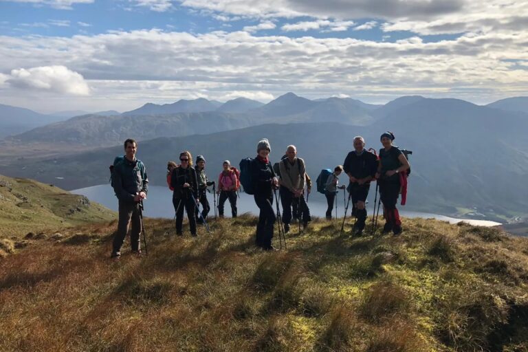
Our Walking Marathon takes place in some of the most scenic places in Connemara! The meeting point for registration and bus collection is at Maam Community Centre and the route is from Killary to Maam Valley mostly along the Western Way. It is mainly a flat walk, the highest point being Maumean at 259 meters, and while about one-third of the walk is on the road the route is chiefly on green road or forest track. There are spectacular views of Killary Fjord, the Maumturks and the Twelve Bens along the route and the walk is a terrific way to experience this part of the country.
- Meeting Point: Maam Community, Teernakill North in Connemara, Co. Galway. H91 W635
- Time: Full Marathon 7:30 am. Bus Departure 8:00 am
- Time: Half Marathon 8:45 am. Bus Departure at 9:30 am
- Price: €50 per person which includes a meal after you finish at the Community Centre.
- Walking boots, wet gear and sunblock, food and refillable water bottle, long distance walking stamina. No dogs allowed.
- Please, Leave No Trace, i.e. no banana skins, orange peel, sweet wrappers, paper tissues, etc.
- Pre-Registration is required to avoid disappointment.
Route Description:
Mainly a flat walk, the highest point Máméan at 259 m, on green road, forest track, one third on minor roads, with spectacular views of Killary Fjord, the Maumturks and the Twelve Bens, a terrific way to experience Connemara. For further information check out our event on Eventbrite at https://www.eventbrite.ie/e/galway-walking-club-marathon-half-marathon-9th-august-2025-tickets-1095448940269 or contact [email protected]
The Marathon is waymarked from start to finish: 42.2 km
Total Ascent 554m taking about 8 – 9 hours
Maam [ Mám ] Community Centre (L 962 523 ) Check-in : 7.30 am. Tea/Coffee available.
Buses leave at 8.00 am (sharp), to bring you to the start of the marathon.
FIRST HALF: 22.0 km/13 mi; 193 m (ascent) about 4 hours
-
Road junction (L 819 605) Start time about : 8.30 am. Follow L5102 (Tullycross) from N 59, for 4.5 km along north shore of Lough Fee. Be aware of traffic coming from behind.
-
Road junction (L 778 624) Take the minor road to the right to Rosroe Pier, going north for 3 km.
-
Checkpoint 01: Rosroe (L 771 649). Follow the track eastwards beside Killary Harbour [Caoláire Rua] for 4 km, to a minor road for another 3 km, to rejoin the N 59 road. Be aware of traffic on N59. Turn left, walk for 100m to the Quarry on the right.
-
Checkpoint 02: Disused Quarry (L 823 607) Water Refill Station. 15.3 km/9.5 mi walked. Walk along the N 59 north eastwards for just 650 m. Watch out for the fast traffic coming towards you!
-
Road junction (L 827 612) Sharp turn to the right on to a minor road L51021 (Glencroff). After 600 m you meet the “Western Way”, which is way-marked with ‘Yellow Walker’ posts. Follow the Western Way for the rest of the walk. A short boardwalk leads to a footbridge over a stream, then southwards on a forest road for 4 km.
SECOND HALF: Follow the Yellow Walker 20.2 km/12.5 mi; 361 m (ascent) about 4 hours
The Half Marathon walkers join the route here, walking back to Maam Community Centre.
-
Checkpoint 03: Tooreenacoona (L 825 572). This is at a small bridge over a stream just after leaving the forest. Continue along the Western Way, now a well-defined track across dry open peatland, for 5.5 km to the Checkpoint 4. Binn Bhriocáin [ Leitir Breacáin] (668 m) and Cnoc na hUilleann (605 m) on your left, at the heart of the mighty Maum Turks ridge.
-
Checkpoint 04: Uillinn(L 859 534). Water Refill Station. 27.4 km/17.02 mi walked
You can avail of a lift back to base from here. The Western Way track joins a minor road at this elbow for the next 5 km, to Checkpoint 05.
The middle Maum Turks ridge continues on your left, passing underneath Binn idir an Dá Log [ Mulnahogue] (702 m), Barr Sliabh na Ráithe (659 m) and finally Binn Chuiní [ Binn Chaonaigh] (634 m) as you approach the car park.
- Checkpoint 05: – Cut-off at 5:00 pm Mám Éan (Car Park) (L 892 495). Water Refill Station. 32.6 km/20.25mi walked
You can avail of a lift back to base from here.
The Western Way swings sharply to the left (north east) for the main climb of the day … climbing 150 m steadily uphill on a rocky track over a 1.5 km distance to reach the Mám Éan Oratory. This is followed by a corresponding ramble downhill, for 3 km, on a grassy dry bog track until it joins a minor road to cross the Failmore River.
-
Checkpoint 06: Failmore River (Bridge) (L 925 524). Water Refill Station. 37.4 km/23.2 mi walked. (Teernakill River). Y_ou can avail of a lift back to base_. The Western Wa_y_ continues uphill along the minor road, climbing 60 m. Then downhill to meet a T-junction at An Chorr [Cur] (L 936 534). Turn right and follow the minor road for 3 km until you arrive back at the base.
-
FINISH: Maam Community Centre (L 962 523) Be sure to sign out and collect your Certificate.
Event Details
Organiser
Location
This event listing is compiled for informational purposes only and is correct at time of publication. All event information may be subject to change by the organisers and you are advised to contact the organisers directly for the most up to date information before you travel. ConnemaraIreland.com cannot be held responsible for any alterations to the listed information.